 Griffin Post has a few favorite features when using the powerful onX Backcountry mapping app. | Katie Lozancich photo.
Griffin Post doesn’t like getting lost. That’s why he does everything in his power to prepare for a day in the mountains. Luckily, he’s got a pretty powerful tool in the palm of his hand: the onX Backcountry app. Using onX Backcountry allows Griffin to research lines, plan a day, get a good reading on slope angles to manage avalanche risk and share tracks with his ski partners all on his smartphone. We caught up with Griffin to chat about his favorite features in the app and how they help him stay safe in the mountains.
Slope Angle Shading
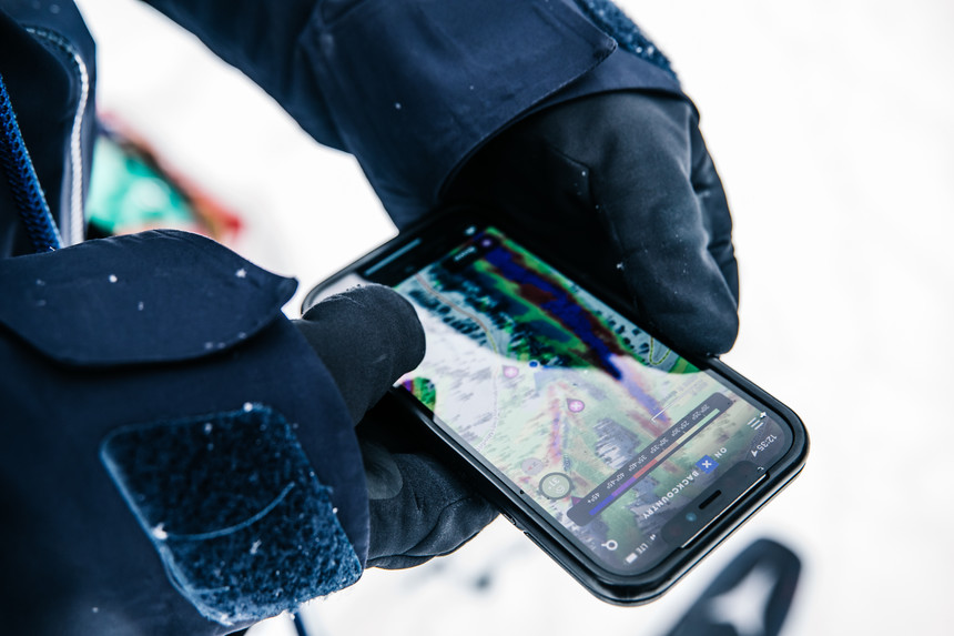
Slope angle shading might the single most useful feature of onX Backcountry while out in the field. When you’re traveling through the mountains in the winter, it’s imperative to know slope angles in order to get a sense of what is avalanche terrain. Often, the difference between a 25 and a 35-degree slope can be hard to tell just by looking at it, so Griffin will turn on the slope angle map overlay to see what is steep enough to slide. Additionally, it gives him an idea if there is any unseen overhead hazard if he is touring up a canyon that might have hidden terrain above seemingly mellower terrain. The app color codes terrain with simple visual clues. Green is generally low angle terrain, yellow is approaching 30 degrees, and anything else is steep enough to slide.
“When I’m heading into a new zone, looking at slope angles can highlight not just the big start zones of avalanche paths but also small terrain features that can also be trigger points,” shares Griffin.
3D Mode
Paper maps are great and all, but nothing beats the ability to see a map in three dimensions. OnX’s 3D mode allows you to do just that, while zooming and rotating to be able to look at a mountain from any angle. When scoping for lines, or even as a secondary reference in the field, Griffin turns on 3D mode to help visualize where he’s going. OnX’s high resolution satellite imagery allow him to see the intricacies of a line, down to details like which tree or rock marks the entrance to line.
“The 3D mode, especially with the snow layer, just takes the guesswork out of figuring out the intricacies of a line as opposed to using an old-fashioned topo map. You can just zoom right in and see the entirety of a line to be aware of hazards of interesting features to hit,” Griffin says.
 Checking out lines in 3D mode before ever stepping foot into the mountains gives Griffin a pretty accurate picture of what he's getting himself into.
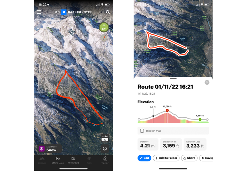
Tracking and Route Planning Tools
Exploring new terrain is one of the biggest reason Griffin loves to ski but entering uncharted territory can be daunting. Luckily, onX Backcountry's route-planning tools can be a huge help. Both the mobile app and the desktop site let Griffin draw a route through unfamiliar terrain to get a sense of what lays ahead. Once a line is drawn, onX Backcountry calculates the distance and elevation profile which Griffin can use to plan his day. Out in the field, the app can also track your route. While it’s not a feature Griffin uses every day if he's skiing in familiar terrain, he says it is incredibly useful for super-accurate tracks or later reference to share with his friends.
“I always have friends visiting from out of town, and while I can’t always just go show them, it’s really easy to share beta for them to go out on their own,” says Griffin.
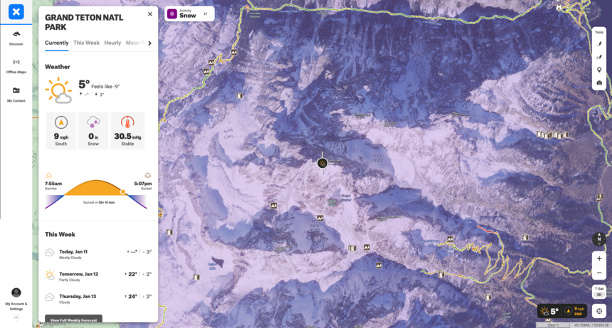 Weather data is crucial, and onX Backcountry presents all the relevant high-level information in an easy-to-read format.
Weather and Avalanche Forecast
Within the app and on the desktop site, onX Backcountry displays local real-time weather and forecasts as well as the avalanche forecast for that zone. Selecting a spot on the map generates a detailed forecast for that area, including hourly temperature, wind, snow, and pressure data as well as the avalanche hazard rating issued by the local avalanche center. Weather plays an important role in any day in the mountains and having hourly data can give Griffin an idea for what snow surface conditions will be or whether a window will open for an objective. Secondly, it can be tough to find weather or avalanche forecasts for international destinations far away from home, so having one reliable place to get a basic forecast can take a lot of the guess work out of the equation.
A specific weather feature Griffin loves is the ability to show wind direction for a specific spot. “When you drop a pin you can select wind flag to show wind direction atop a peak or in a zone,” he says.
 Sharing a line or other data in the app is as easy as pressing the "share" button to send it to a friend's device. | Eric Parker photo.
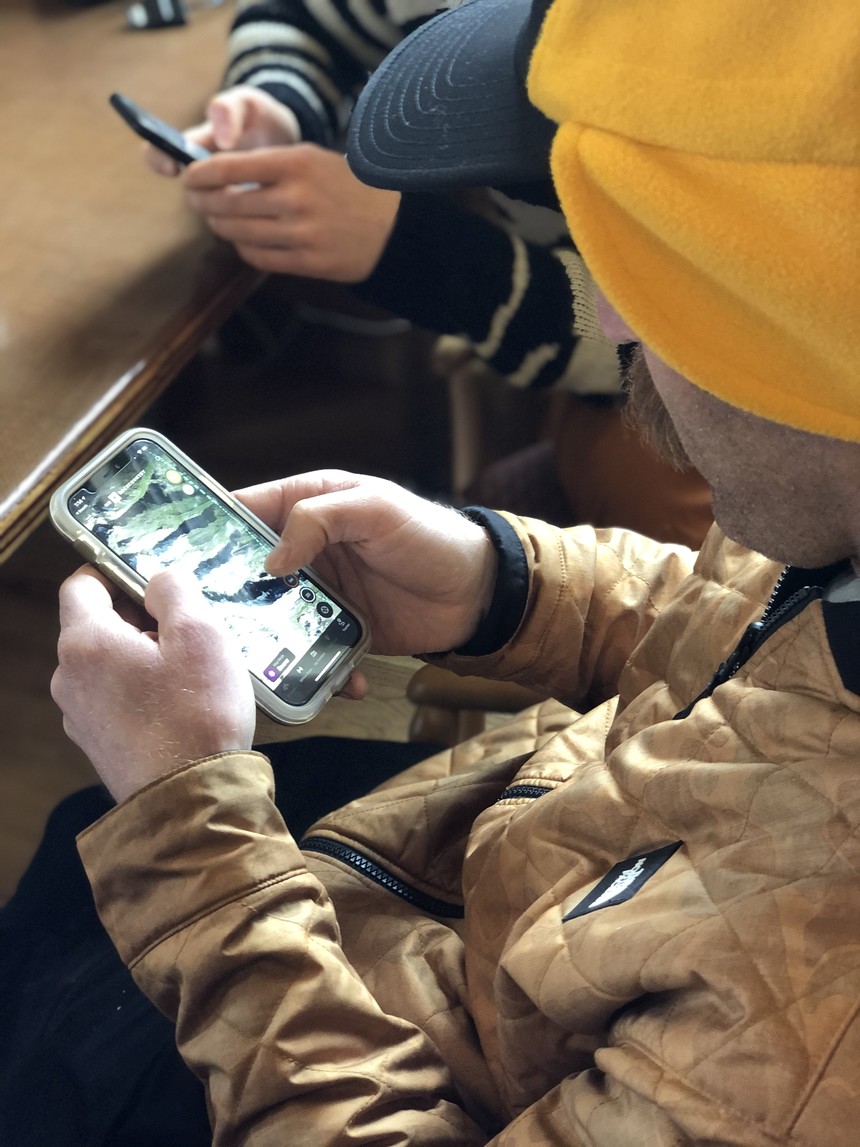
Sharing A Line
The final feature Griffin loves about onX Backcountry is the ability to quickly and easily share information with friends. After drawing a line or planning a route, he can simply click the “share” button. That generates a unique URL that he can share with anyone via SMS or other messaging app. When planning a day with partners this allows the crew to share information on potential objectives or hazards to avoid.
Our friends at onX Backcountry are offering the app for a 20 percent discount using this link.
About The Author
stash member Max Ritter
I manage digital content here at TGR, run our gear testing program, and am stoked to be living the dream in the Tetons.